


On the way to Spiti Valley, the author stops over for a day in Sangla Valley, arguably the most romantic of Himachal Pradesh’s Himalayan valleys.
Iwoke up to a magical dawn. The view through the misty glass window reminded me of a Dutch Renaissance oil painting I had seen at the Louvre.
Our hotel was perched on a cliff overlooking the river Baspa, in the lovely village of Rakcham. I stepped out onto the balcony. The orange of the daybreak was spreading across the space between the snow-painted peaks of two mountains. Like in a 3-D movie, the peaks looked so close from the balcony. A layer of mist that looked like thin, soft smoke, hung over the river. The river banks, paved with white and black and light-yellow pebbles formed over thousands of years, were wider than the fast-flowing river. Beyond the vast spread of the pebbles were the apple orchards and beyond the apple orchards were the deodar and pine forests that climbed up the mountainsides.
The previous night we had driven alongside the Baspa from Karcham, but because of the dark and the fatigue from the long bumpy drive from Theog we had failed to notice the charms of the river and the Sangla Valley, which is also called Baspa Valley. It was around 10 PM that we had arrived at the hotel. I remembered falling asleep listening to the rush of the Baspa waters through the cold, silent night.
Sangla Valley Romantic
Sangla (Baspa) Valley is arguably the most romantic valley in Himachal Pradesh. The river originates in the Baspa hills on the India-Tibet border and runs through the Sangla Valley for 95 km before merging with River Sutlej at Karcham. The Chung Shakhago Pass stands guard to the Baspa at its origins. The river is born, and disappears in the Sutlej, within the Kinnaur district. Kinnauri people used to believe that they had descended from the Kinnaras, the mythological musician-lovers of the human-bird kind. And, the beautiful land of Kinnaur was a gift from above. Kinnaur is surrounded by Garhwal in the south, Tibet in the east, Spiti Valley in the north and Kullu Valley in the west.

In spite of the cold invading through my fleece jacket, I couldn’t resist the temptation to get out of the hotel and walk around the village. My wife came along too. It was early October and winter was struggling to break out. In a couple of weeks, most of this village would be covered with snow, and snowflakes would be dancing around. The deodars and pines and birches would be shivering under their snow blankets. High above the river, a dusty, torn road ran by the mountain’s abdomen and played hide and seek with the river. Two bearded sheepherders, one with a sick lamb held close to his chest, and another with a long wooden stick in hand were driving their large flock of sheep down the road. Stern, hairy sheepdogs kept their charge from straying far. Ahead of the arrival of winter, sheepherders relocate from the upper regions to the lower parts of the valley. In these Himalayan villages, such seasonal migration has been going on for–who knows how many—centuries.
Shadow play
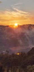
As we walked along the mountain road, a giant shadow play was on in the valley. When the sun rises, the shadows of the peaks fall on the deodar and pine forests and then the shadows of the forests fall on the valley below and the shadow play keeps changing as the sun rises further.
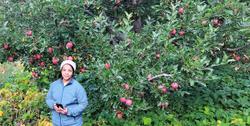
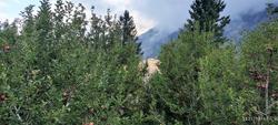
When we turned a bend, up came a beautiful orchard of apples still covered with mist. The other side of the orchard was close to the edge of the river bank. Ripe, dark-red apples hung from the branches. Kinauri apples, generally gown at a sea level of around 10,000 feet, are renowned across the country for their sweetness, succulence and long shelf life. In the middle of the apple orchard was a tall rock that carried the legend, “I love (xyz),” scrolled by an anonymous lover. “If you don’t feel love and romance in this setting, where else will you?” I said to myself.
I don’t know why but in my mind I have always associated the apple tree to a little romance. The first time I saw an apple tree full of fruit was exactly 25 years ago. In Uttarakhand. In a village called Harsil on the banks of the Bhagirathi. On the way to Gangothri. I still remember that full-moon night–we sat around a fire in the courtyard of a wooden hunting lodge built by a British man in the 19th century. I remember Bhagirathi’s waters flowing shallow across an apple orchard and reflecting the moon broken by the apple branches. (Years later, when I bought a house in Kochi, Kerala, it was named Harsil.)

We rushed back to the hotel as it was getting late to travel to Chitkul, the last inhabited Indian village on the Tibetan border. Our driver Jaggu Bhai (Jagmohan) was getting impatient. Still, we managed to go down to the river wading across the spread of large pebbles and cross the river by the iron bridge.
Pines, firs and deodars
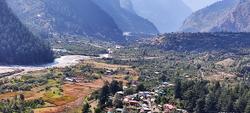
The upper ranges of the Baspa river remain under the snow for most part of the year, but some stretches never come out of the snow cover at all. Deodars, blue pines, firs and silver birches rise up in the upper reaches. In the lower ranges, tiny villages and little Buddhist and Hindu temples coexist with orchards of apples and other fruits. The lower ranges of the valley are fertile and relatively prosperous. Millet, potatoes and buckwheat are the main food crops. Sangla, the largest village downstream, is the main shopping centre for the entire valley. The pine nuts of Sangla Valley are said to be highly nutritious. Exotic, vibrant mountain flowers add to the charm of the valley.
At one end of the (inhabited) Sangla Valley is Chitkul and at the other is Karcham.
Chitkul is a little over 10 km from Rakcham. But, the narrow, rocky road that runs parallel to the Baspa is tough and tricky. The edge of the road is often shaky and a slight slip would mean rolling down the rocky hillsides. But the remarkable views of the mighty mountains on the left, right and front and the beautiful valley and the greenish-white waters of the Baspa more than compensated for the scare caused by the drive.

The Last Village
Chitkul is called The Last Village. What this means is that it is the last inhabited Indian village on the India-China border, in Himachal Pradesh. China’s Tibet Autonomous Region, the highest region on the earth, is around 90 km further away. The territory beyond Chitkul is under the strict control of the Indo-Tibetan Border Police (ITBP) and ordinary civilians are not let in, without a valid pass. Chitkul, which lies on the right-hand bank of the Baspa at a height of 11,320 fett, is the last village in the Sangla Valley.

“Wow, Chitkul,” we exclaimed as we passed through the Chitkul village panchayat’s welcome arch. The village is supposedly home to the cleanest air anywhere in an inhabited place in India. The village has the snow-capped Kinner Kailash mountains as its backdrop, and all around you can see mountains partially covered by snow. No wonder the village has the cleanest air. And later, after a sip of the water from the Baspa that is fed by glacial streams, I thought Chitkul perhaps possessed the purest drinking water too.
As we pulled up in the middle of the village, which is some 200 metres away from the river, a flock of sheep was lazying around under the watchful eyes of the sheepdogs. The herders were sipping tea standing by a local café and making calls on the mobile. At 11,300-plus feet height, the calls were still clear and audible. The village had a number of small lodging houses, mainly meant for young trekkers. Residential houses were small too, and many had slate roofs. Two small temples, one Buddhist and the other Hindu served the roughly 800 population. When the winter intensifies and the village is covered by snow, a sizeable chunk of the population would relocate to Sangla or other towns below.
Chitkul is a hub of trekking. Some of the famous trekking routes in the region begin here. The Borassa Pass trek, at a height of nearly 18,000 feet, is one of the toughest. The Lamkhaga Pass trek takes at least 15 days. The Rani Kanda Meadows is just 10 km from Chitkul and this trek is of medium difficulty. For beginners, Nagari ITBP trek is the best.
In fact, there are not many things `to see’ in this romantic village, but a lot of things `to feel.’ The biggest attraction of the village is its location. For me, a walk on naked feet on the vast, pebble-strewn river banks, a hand dip in the snowmelt waters, a sip of the pure water from the glaciers, and watching the open, clear sky paid for the visit.
Worm in the apple
On our way back, we could see almost the entire stretch of Sangla Valley from Chitkul to Karcham in full daylight. From the tortuous road high up along the waist of the mountain, we kept on looking at the valley and the Baspa below. The play of the afternoon sun in the valley, which looked like a long corridor between two lofty mountains, was intriguing. The occasional, tiny villages below looked like abstract paintings. Orchards of apricot, walnut and apple greeted us along the way towards Sangla town. The Sangla area is also known for saffron farms, Tibetan wood carving and angling in the Baspa.
Close to the confluence of the Baspa and the Sutlej is the gigantic 1000 MW Karcham-Wangtoo hydroelectric project. I thought of the project as a worm in the apple.


